
tracking services
VEHICLE TRACKING
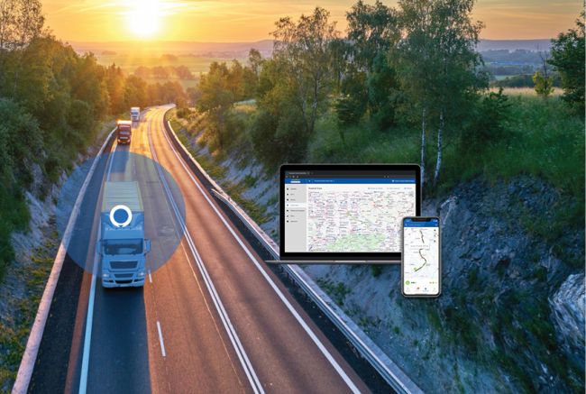
Track Vehicle Events as They Happen in Real-Time
The Vehicle Events feature in UniTrack 24 enables fleet managers to view real-time fleet events (statuses) as they happen in real time such as when a vehicle’s is turned on or off, including the date/time of the occurrence and the location. As vehicle events occur, the data is organized right beneath the map, in the Data View, showing the most recent status at the very top of the log.
MOBILE TRACKING
Fully hosted, No software to buy or install. Track and control your assets over the web or on your mobile from any part of the globe. Ready to use GPS hardware is shipped to start tracking your assets. directly on the interactive map to give full geographic context of driver activity: where they’ve been, for how long and more
FLEET MANAGEMENT
Find Your Fleet’s Geographic Locations On Demand.
The Vehicle Locate feature in UniTrack 24 automatically pushes real-time fleet updates to UniTrack 24 such as current engine statuses and event times registering them on the map and on the Data View. Fleet managers can choose how often they receive data via pre-set frequencies or by manually requesting a locate for any vehicle on the map, at any time.
FLEET MANAGEMENT Features
REPORTS | SUMMARY
- Consolidated Report Consolidated report containing all the essential parameters of travelling
- Geofence Report Geofencing In/Out report for the trackers
- Trips Report Computes various trips done by the tracker and reports with complete statistics
- Events Report Reports all the events generated by the tracker in the specified period
- Overspeed Report Reports all the speed violations done by the tracker
- Fuel Analysis Report Computes fuel consumption report for a tracker
- Temperature Analysis Report Computes statistics of the temperature recordings
- Idling Report Reports all the places and the durations where vehicle was idling
- Stopover Report Reports all the places and the durations where vehicle was stopped
- Current Fleet Report Generates report with all the positions and status of your current fleet
- Job Allocation Report Shows all the completed and scheduled jobs for the specified period
- Summary Report Shows history of the path taken in textual format
- Journey Report (Vehicle) Reports all the journeys based on Odometer and business/private mode
- Journey Report Reports of all the journeys based on Driver, Odometer and business/private mode
- Path Completion Report Display completion report for the scheduled path(s)
- Accident Report In case of an impact this reports shows the pre-impact and post-impact analysis
- Overspeed Report (Ex)Extended Overspeed report with distance, duration and maximum speed reached
- Overspeed In Geofence Overspeeding violations in hardware geofence areas
- Trip Report (Single Line) Detailed trip report with support of private and business distances
- Driver Scoring Report Calculates the score of the drivers based on their driving performance
- Engine HoursCompute Working Engine Hours
- Driver Work Report Computes work done by a driver
- Driver identification
- Alert on different incidents like battery change due, tyre change due etc.
- Alert on insurance renewal due, fitness renewal due etc.
- Route optimisation
- Expected Time of Arrival (ETA)
- Adding landmarks (POI) for easy identification of places
- Geofence drawing, speed limit inside geofence and alert on geofence entry and exit
- Different kind of reports which can be scheduled on email and also exported in HTML/PDF/EXCE
- Driver behaviour analysis and much more